~44 miles @ ~18 min/mi
"It's a Latrine of Legend! The Taj Mahal of Toilets!" I proclaim to all who will listen to me at the mile 23 aid station. A few minutes later when I reach the loveliest loo on the Appalachian Trail I pause to enjoy the electric lighting, stalls with doors, rolls of toilet paper, flush commodes, and warm water for hand-washing. Magnificent!
The Quad State Quad Buster is a VHTRC-sponsored fun run down the AT from Pennsylvania through Maryland to West Virginia and then into Virginia. It ends with a few bonus miles along the Loudoun Heights Trail. Dead Last (or "DFL!" as friend Caren Jew taught me to describe it) is how I complete the 2010 QSQB, with an elapsed time of 13:22 for 44.3 miles by my GPS. I spend ~5 minutes in PA, 10:55 crossing MD, ~20 minutes in WV, and the remaining ~2 hours stumbling through the woods at night in search of the finish line. The trackfile map shows the route.
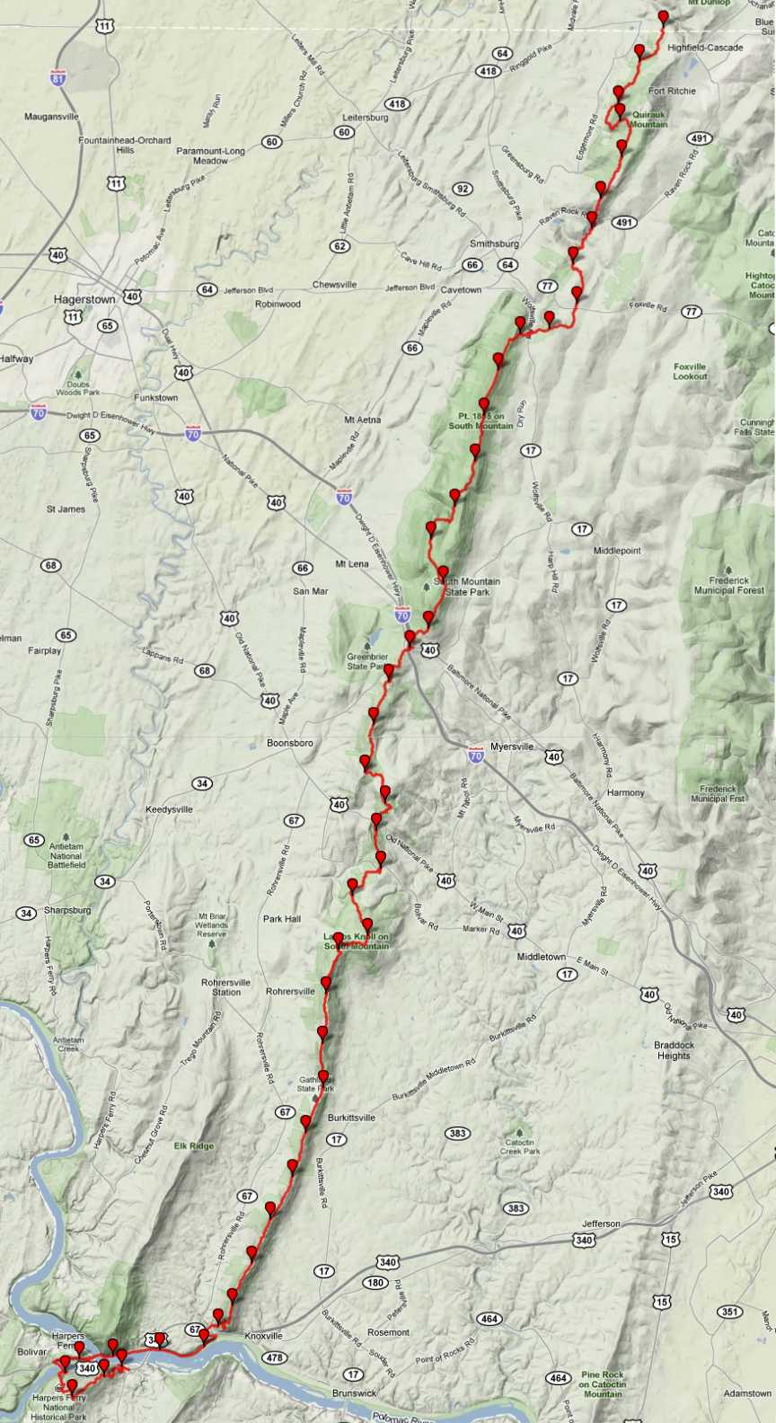
markers every mile - GPS trackfile mapping by GPSvisualizer - background terrain map by Google
Runs with Friends
A nearly-full moon sets in the west. At 0530 Saturday morning I park cautiously on the shoulder of US-340 behind half a dozen cars and pickup trucks. Race Director Michael Bur orchestrates the action here on the southern shore of the Potomac River. Comrades Karen Taber and Caroline Williams shiver with me in windbreakers and shorts. We pile into volunteer vehicles and carpool to the Mason-Dixon Line, almost an hour's drive north. In the back of Ben Thompson's noisy jeep his big black Labrador retriever named "Huckleberry" licks my ear as I nibble a Clif Bar and drink a Cherry Coke. Ben tells us about his through-hike of the Appalachian Trail, south-to-north, April-September last year. He's injured and can't run today.
At Pen Mar Park runners clamber out and prepare themselves; I almost trip over a trail buddy squatting behind a car. We line up for photos and at 7:10am Bur gives the "Go!" signal. Soon the faster folks are out of sight. After a few hundred yards Karen and I pause to admire a lovely vista to the west. Soon thereafter Pat Miller, Caroline, and Karen dash ahead with me in pursuit. "Hey," I call to them, "the sign here says the AT turns left!" We reassemble and proceed up a rocky slope, past campers crawling out of tents and fixing breakfasts. Within the first mile I trip on a tree root and fall onto my hands, fortunately without significant damage. It's my only tumble of the day. After three miles of steepness we're at the top of Quirauk Mountain and proceed to follow white blazes along the ridge southwest. Runners Paul Crickard, Edward Cacciapaglia, Dave Yeakel, et al. now catch up and pass us. They tell us that they got lost on the way to the start and began ~15 min late.
Nine miles into the run Karen and Caroline are out of sight ahead when I notice blue streamers hanging from a tree. Is this the first QSQB Aid Station? (Maybe I should have read the course description and paid attention at the pre-race briefing?) I take a few steps along the side path, lose confidence, turn back, and at the fork see a small wooden sign that says "PARKING LOT". I shout "Hello!" but hear no response. After a few more moments of dithering I decide to gamble and follow the blue ribbons. A quarter mile later I emerge from the woods at Wolfsville Rd and discover a van with cheerful volunteers who record my arrival, refill my hydration backpack, and offer me food. I tell them that Karen and Caroline have gone onward and are all right. Fortified with a handful of M&Ms, I fill my pockets with packages of cheese-and-honey crackers and Halloween candy. Then I scurry back to the AT.
The next big climb takes us onto South Mountain. Halfway up I find Caroline and Karen. They report that they saw the ribbons but like me didn't know there was an aid station nearby. They decline my offer to share water but accept a little candy. Caroline regrets missing her drop bag; Karen gives her some of her Clif Bar supply. The trail crosses a power line right-of-way and then a grassy meadow where two small black-and-white cows and a steer are grazing. I eye them warily and try to confirm that the one is a peaceful steer and not an aggressive bull. The creatures eye us warily as we trot by.
Back in the woods again Caroline and I slow down as Karen zooms ahead. This is really just a training run for Caroline, who has been doing long races recently and has the Marine Corps Marathon coming next weekend. She slows and I tell her I'll go onward to find out how Karen's doing. (That's the last I see of Caroline until she materializes, cheerful as always, at the Weverton Aid Station two dozen miles ahead; she dropped from the race and hitched a ride there.)
Chasing Cutoffs
After another rocky climb I spy Karen and close the gap with her. She tells me, wisely, that we need to push the pace if we're going to make the time limits. On semi-runnable stretches she leads the charge. I roll an ankle, but not seriously; Karen stumbles and falls, but shakes it off and continues strong. We manage a couple of 13 minute miles according to my GPS. Tourists begin to appear along the trail and we figure we're nearing the next aid station, at South Mountain State Park where the AT bridge goes over I-70 and US-40. I run ahead and see the blue ribbon markers, follow RD Bur's instructions that I remember from the start, and arrive at QSQB Aid Station #2. Karen comes in shortly behind me. We're 10 minutes ahead of the first cutoff according to the timekeeper here. We refuel, refill water bladders, thank the Aid Station folks, return from the parking lot to the AT, and cross the bridge over the Interstate highway. I Tweet at 12:10 reporting progress: five hours into the race, 18+ miles completed, an average pace of 16+ min/mi.
Now the going gets tough again. Karen sends me on ahead at about mile 19; before we part I confirm that we have each other's cell phone numbers. I tell her to look for me at the next aid station, a few miles ahead. The AT leads me through Washington Monument State Park, where I lose the trail a couple of times but cast about and soon manage to find it again. Tourists abound. Up and down through piney woods I go, looking back for Karen without luck.
QSQB Aid Staton #3 is at US Alt-40, in the Old South Mountain Inn parking lot, mile 23 by my reckoning. At last I'm in known territory: the JFK 50 Miler course goes through here, and it's a place where I've also done several training runs with friends along the trail. Pat Miller and Dave Yeakel are refueling, so I tell them about the wonderful restrooms on the AT nearby.
Dave passes me again near the the Reno Monument Road crossing. The JFK 50 Miler follows the road here; I miss the turn-off for the AT. After a quarter mile of befuddlement I ask directions from a park ranger and backtrack to find the trail at the small parking lot. The AT's up-and-down route is far more rugged than the JFK's. After a tough climb to the radio tower where the JFK rejoins the AT I pause at an overlook and say "Wow!" aloud to myself before I see a hiker with a dog nearby.
The next aid station is at Gathland Gap, aka Gapland, mile 30 according to my GPS. My watch says 3:37pm, three minutes within the official cutoff. Race Director Bur sends me on my way. During the climb out my phone rings: it's Karen Taber, reporting that she's still making progress but is now more than a mile behind. I encourage her, but sadly she reaches Gapland too late and has to stop. It's the inverse to our experience at Cheat Mountain two months ago, where I miss the final cutoff and Karen makes it by a hair.
Onward I trek, running on the few stretches where it's safe. Approaching Weverton Cliffs I pass the point where I broke my arm during a training run with Kate Abbott. I tread cautiously and call Kate to let her know of my progress. (Unprompted, she denies pushing me and causing my fall; I claim amnesia.) Here I also remember the place where I caught up with Caren Jew during the 2006 JFK, and phone her to chat and reminisce. I call home to give Paulette a status update.
Maryland Challenge
At Weverton I reach the final QSQB Aid Station, my mile 37. Dave is here, as is Keith Knipling who has already finished the entire race. He acts coy when I ask him when. "Oh, just a few hours ago," he says. He reminds me to look out for the blue blazes that mark the final course segment, where the Loudoun Heights Trail leaves the AT. I refuel and head out. The AT now goes under US-340, crosses the train tracks, and joins the C&O Canal towpath.
As it has for much of the day, the chorus of the Sophie B. Hawkins song "As I Lay Me Down" runs through my head:
As I lay me down to sleep
This I pray
That you will hold me dear
Though I'm far away
I'll whisper your name into the sky
And I will wake up happyI wonder why I feel so high
Though I am not above the sorrow
Heavy hearted
Till you call my name
And it sounds like church bells
Or the whistle of a train
On a summer evening
I'll run to meet you
Barefoot barely breathing
Occasional interludes of Matt Nathanson's "Come On Get Higher" fight their way into the foreground, then recede.
Along the flat towpath I make haste, running four minutes and walking one to achieve ~11 min/mi average pace. The Potomac River is noisy with rapids and geese on my left hand. After another passage under US-340 I see the pedestrian bridge to Harpers Ferry WV in front of me sooner than expected. As I climb the stairs and start to cross my watch reads an elapsed time of 10 hours 59 minutes. Can I make it across the state of Maryland on the Appalachian Trail—"The Maryland Challenge"—in under 11 hours? Past tourists ambling the other way I sprint. The state of Maryland extends to the southern edge of the river, so only after I reach the far side of the ramp and bend down to touch West Virginia soil with my fingertips do I check my GPS timer. It reads 10:59:50 ... yay!
Later trackfile analysis shows that the race this year actually begins at 39.7209 north latitude, more than a quarter mile inside Pennsylvania. It takes me about 5 minutes to get into the Free State from our 7:10am start, so I actually make the crossing in about 10:55, including half a mile or so of off-AT diversions to aid stations and wrong turns.
Alone in the Woods at Night
In Harpers Ferry I immediately lose the AT and proceed south along the freight train tracks. I wander about for several minutes and eventually, back at the bridge over the Potomac, spy white blazes leading west along a street. In the deepening gloom I climb steep stone stairs past an old church and Jefferson Rock, follow the AT along a cliffside, and descend to take it via the US-340 bridge across the Shenandoah River.
Now the sun has set and it's getting dark. I'm tempted to throw in the towel and walk along the shoulder of the highway back to my car. (I later learn that Pat Miller sensibly chooses to do so.) But fool that I am, I turn my headlamp on and proceed up the hillside following the white blazes. My pace now slows to 30-40 min/mi. I remember the murky woods I experienced in the 2010-04-03 - Chocolate Bunny run, and rediscover the best way to tell when I've wandered off-trail: the crunching sound of leaves underfoot gets louder.
Dave Yeakel once more catches up and passes me. He has run this trail in daylight, he says, but admits that it's a lot tougher at night. I follow slowly behind until, far ahead, he shouts down that he has found the Loudoun Heights Trail that takes us to the finish. His light vanishes and I'm all alone again.
The full moon rises in front of me and casts avenues of light between the trees. Every few minutes a big leaf falls through my flashlight beam and looks like a bat, making me jump. My pace slows as I scan for blue blazes which fortunately are frequent. I try not to fall down.
At last I see orange ribbons hanging from a tree, but don't know what they mean and continue along the official trail until it ends at US-340. I head first east, then west until I glimpse my car parked by the road. I phone the Race Director and he tells me that they're still waiting for me at the parking lot. So I turn back and trot along the shoulder as cars whiz past. At a total time of 13 hours 22 minutes—44.3 miles by my GPS—I shake Bur's hand and finish. My prize: Bur gives me a cup of warm veggie soup that his wife made. It's great!
Split Statistics
GPS timing information for my miles during the QSQB: 13:27 17:40 25:02 14:51 14:08 21:54 17:50 20:02 13:43 20:08 17:48 13:18 16:58 13:02 17:17 11:48 12:59 18:05 17:47 15:15 15:55 17:34 20:24 16:07 16:08 23:27 19:18 17:12 14:42 17:04 16:28 16:08 17:12 15:49 17:39 21:46 16:24 11:07 10:57 17:15 17:04 41:28 30:23 31:54 — plus 8:59 for the final 0.37 mi segment.
(cf. GPS trackfile, ...) - ^z - 2010-10-30